


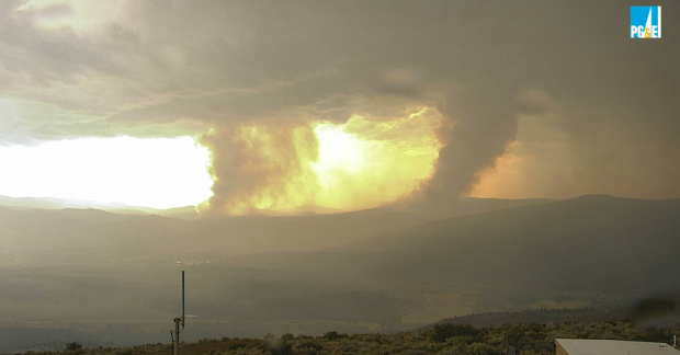
- A dramatic image taken from the AlertWildFire.org camera on Antelope Mountain shows the two flanks of the Hog Fire, (the left near Devil’s Corral and the right on Roop Mountain) with Susanville in the foreground during this evening’s thunderstorms.

Updated Friday, 3:31p.m.
Firefighters continue to strengthen control lines, provide structure defense and engage in tactical patrol on the Hog Fire which has only grown to 9,540 acres is 38% contained.
Warm weather and dry conditions may increase the risk of fire activity from smoldering areas. Potential still exists for spots to become established outside of the control lines. Damage assessment teams continue to evaluate the affected area.
As some residents are allowed to return to their homes, please drive carefully as emergency personnel are still working throughout the fire area.
Updated 6:52p.m. Effective immediately, the Mandatory Evacuation for the community of Lake Forest Estates has now been downgraded to an Evacuation Warning for residents only.
There will be a road closure at County Rd., A-1 just north if the water tanks.
Be aware and that changing conditions in fire activity may cause this area to return to an Evacuation Order at any time.
Be aware that traffic interruptions may exist due to fire and utilities equipment working in the area.
Updated 4:03p.m.
The existing evacuation order remains in place. Due to hazards rendering the area unsafe, a new MANDATORY EVACUATION ORDER has been issued for the following area:
West of Junction SR-36 and SR-44
SR- 36 east of Fredonyer Summit
This includes all roadways and trails accessed by SR-36 and SR-44
All trails along SR- 36 will remain closed. This includes Bizz Johnson Trail
A MANDATORY EVACUATION ORDER remains in the area of:
All residents served by A-1 Road, north of SR- 36, including Lake Forest Estates
The following area has been downgraded to an EVACUATION WARNING:
Junction SR- 36 and SR- 44 east to the A-1 SR-36, this encompasses River Bench, Britt Lane, Thumper Hill Road and Ridge Top Road
West of Brake check area on SR-36, to the junction of SR-36 and SR-44, this includes residents served by Phil Dow Road.
STATE ROUTE 44 IS NOW OPEN FOR TRAVEL: Please drive carefully as emergency personnel are still working throughout the fire area
Updated Thursday, 7:02a.m.
According to fire officials the Hog Fire has minimal growth overnight and crews are continuing to establish control lines utilizing dozers and hand crews in steep, rugged terrain.
The acreage did not increase after last night’s mapping, and the fire size is still estimated at 9,517 acres with 26% containment.
Updated 9:02p.m.
The Hog Fire grew by only a hundred acres today, mapped at 9,517 acres in Cal-Fire LMU’s evening update, with 23% containment.
According to fire officials the fire remained active throughout the day and personnel are establishing control lines utilizing dozer and hand crews in steep rugged terrain.
Strong thunderstorms around the fire area brought rain, hail and lightning.
The storms helped keep fire activity down, but it continues to burn due to dry fuels.
Personnel will continue to work tonight to establish and bolster containment lines within the limits of the projected thunderstorm activity.
The fire is still 5 miles from Susanville.
There are no changes to evacuations or road closures.
This is live coverage of a breaking news event. This post supersedes our earlier post and will be updated with new information when it becomes available.
Updated Wednesday, 7:34a.m.
The Hog Fire grew only slightly overnight with Cal-Fire officials saying this morning that the fire, burning 5 miles west of Susanville, is 9% contained at 9,420 acres.
According to the agency’s morning update firefighters are continuing to take suppressive action and construct containment lines.
Tuesday, 8:23p.m.
Firefighters on the 9,000 acre Hog Fire faced extreme fire weather this afternoon as a round of thunderstorms delivered strong, gusty outflow winds over the area.
The good news is that for most of the afternoon the fire burned in a northwesterly direction, west of the Lake Forest community.
At around 5:00p.m., lightning and wind near the fire forced officials to suspend most air operations on the blaze which is 7% contained with no estimated date for containment.
Weather radar from NOAA appeared to show some moisture directly under the storm cores, but with dry lightning and gusty winds along their periphery. Social media posts from Lake Forest residents shows heavy rain falling during the storm.
The round of brutal thunderstorms left a series of small vegetation fires as it made its way from the Doyle area up the valley to Susanville.
Plumas County is also experiencing thunderstorms and new fire starts this evening.
Firefighters made quick work of most of the new starts and are still working on several small vegetation fires behind Janesville and Milford. Radio traffic indicates that rugged terrain along the ridges are hampering efforts of firefighters to reach the spot fires.
Evacuations
Lassen County Sheriff Dean Growdon has issued MANDATORY EVACUATION notices to the community of Lake Forest Estates and both the north and south sides of Highway 36 from A-1 to Willard Creek Road. An evacuation center has been set up at Lassen Community College. For shelter information call (530) 250-9088.
Several rumors circulated throughout the community today prompting Interim City Administrator Kevin Jones to issue a statement reassuring residents that there are no immediate plans to evacuate any part of Susanville. The fire, at its closest point, is still five miles away from Susanville.
According to Cal-Fire LMU’s evening update firefighters are continuing to build containment lines around the fire, which remained active throughout the day.
Road Closures
Highway 36 is closed from the Highway 36/44 junction to County Road A-21.
Highway 36 is closed from Highway 44/36 juncture to Westwood.
County Road A-1 is closed from Gallatin Road to Highway 36.
Agencies working on the fire include Cal-Fire LMU, Lassen National Forest, California Highway Patrol, Lassen County Sheriff’s Office and CalTRANS.
There are currently 147 engines, 31 water tenders, 21 hand crews, 33 dozers and 1,087 total personnel working on the fire. Numerous firefighting air tankers from throughout the state are flying fire suppression missions as conditions allow.
LMUD Outage Alert
As of 8:00p.m. LMUD crews were responding to several small outages in their service territory. If you are experiencing an outage, please call 530-257-4174.
Telecommunications
Telecom technicians worked in the fire area today and have restored service to most of Susanville’s internet and cell phone customers who lost their connection yesterday when the fire burned through fiber-optic cable near Highway 36.
This is live coverage of a breaking news event. This post will be continuously updated as new information becomes available.


